


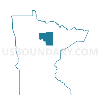
Stokes Twp. Voting District, Itasca County, Minnesota
About
Outline

Summary
| Unique Area Identifier | 602600 |
| Name | Stokes Twp. Voting District |
| County | Itasca County |
| State | Minnesota |
| Area (square miles) | 57.28 |
| Land Area (square miles) | 52.47 |
| Water Area (square miles) | 4.81 |
| % of Land Area | 91.60 |
| % of Water Area | 8.40 |
| Latitude of the Internal Point | 47.67879440 |
| Longtitude of the Internal Point | -93.66995980 |
Maps


Graphs
Select a template below for downloading or customizing gragh for Stokes Twp. Voting District, Itasca County, Minnesota


Neighbors
Neighoring Voting District (by Name) Neighboring Voting District on the Map
- Bigfork Twp. Voting District, Itasca County, MN
- Lake Jessie Twp. Voting District, Itasca County, MN
- Liberty Twp. Voting District, Itasca County, MN
- Marcell Twp. Voting District, Itasca County, MN
- North Unorganized Prec., Itasca County, MN
Top 10 Neighboring County Subdivision (by Population) Neighboring County Subdivision on the Map
- Northeast Itasca UT, Itasca County, MN (1,179)
- Marcell township, Itasca County, MN (467)
- Bigfork township, Itasca County, MN (321)
- Lake Jessie township, Itasca County, MN (303)
- Stokes township, Itasca County, MN (230)
- Liberty township, Itasca County, MN (62)